Categorieën
- Nieuwe artikelen
- Boeken
-
Kaarten
- Camperkaarten
- Educatieve kaarten
- Fietskaarten
- Fietsknooppuntenkaarten
- Historische Kaarten
- Pelgrimsroutes (kaarten)
- Spoorwegenkaarten
- Stadsplattegronden
- Toerskikaarten
- Topografische kaarten
- Wandelatlassen
- Wandelkaarten
- Wandelknooppuntenkaarten
- Waterkaarten
- Wegenatlassen
-
Wegenkaarten
- Afrika
- Azië
-
Europa
- Albanië
- Andorra
- Armenië
- Azerbeidzjan
- Belarus - Witrusland
- België
- Bosnië - Hercegovina
- Bulgarije
- Cyprus
- Denemarken
- Duitsland
- Engeland
- Estland
- Faroer
- Finland
-
Frankrijk
- Picardie - Noordwest Frankrijk
- Hauts-de-France
- Grand-Est
- Champagne - Ardennen
- Normandië
- Bretagne
- Pays de la Loire
- Dordogne - Limousin
- Franse Atlantische Kust - Nouvelle-Aquitaine
- Aquitaine
- Limousin
- Poitou-Charentes
- Vogezen - Elzas - Lotharingen
- Île-de-France
- Bourgogne - Franche-Comté
- Franche-Comté
- Bourgondië
- Auvergne - Rhône-Alpes
- Auvergne
- Rhône-Alpes
- Franse Alpen
- Alpen - Mont Blanc - Haute Savoie
- Alpen - Vanoise - Savoie
- Alpen - Vaucluse - Drome - Vercors
- Pyreneeën
- Occitanie
- Languedoc - Rousillon
- Cevennen
- Midi-Pyrénées
- Centre - Val de Loire
- Provence - Alpes-Côte d’Azur
- Cote d'Azur - Franse Riviera
- Provence
- Corsica
- Lyon
- Parijs
- Rennes
- Straatsburg
- Georgië
- Griekenland
- Groenland
- Hongarije
- IJsland
- Ierland
- Italië
- Kosovo
- Kroatië
- Letland
- Liechtenstein
- Litouwen
- Luxemburg
- Malta
- Moldavië
- Monaco
- Montenegro
- Nederland
- Noord-Ierland
- Noord-Macedonië
- Noorwegen
- Oekraïne
- Oostenrijk
- Polen
- Portugal
- Roemenië
- Rusland
- Scandinavië
- Schotland
- Servië
- Slovenië
- Slowakije
- Spanje
- Tsjechië
- Turkije
- Vaticaanstad
- Zweden
- Zwitserland
- Midden-Amerika
- Midden-Oosten
- Noord-Amerika
- Oceanië
- Wereld
- Zuid-Amerika
- Wintersportkaarten
- Opruiming
- Puzzels
- Travel Gadgets
- Wandkaarten
- Wereldbollen
Veilig online betalen
Betaal veilig via uw eigen bankomgeving
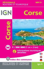
Wegenkaart - landkaart 19 IGN Mini Map Corse - Corsica | IGN - Institut Géographique National (9782758551034)
- ISBN / CODE: 9782758551034
- Editie: 12-10-2020
- Druk: 11
- Aantal blz.: 1
- Schaal: 1:250000
- Uitgever: IGN - Institut Géographique National
- Soort: Wegenkaart
- Serie: IGN Mini Map
- Taal: Engels, Frans
- Hoogte: 12.0 cm
- Breedte: 12.0 cm
- Gewicht: 29.0 g
- Bindwijze: -
- Uitvoering: Papier
- Schrijf als eerste een review
-
€ 6,95
Leverbaar in 3 - 5 werkdagen in huis in Belgie Levertijd Nederland Leverbaar in 3 - 5 werkdagen in huis in Nederland Levertijd Belgie
Gratis verzending in Nederland vanaf €35,-
- Afbeeldingen
- Inkijkexemplaar
Beschrijving
Goed leesbare wegenkaart van Corsica. Anders dan de gewone kaart is deze in klein formaat gevouwen, past makkelijk in je jaszak.
Reviews
Geen reviews gevonden voor dit product.
Schrijf een review
Graag horen wij wat u van dit artikel vindt. Vindt u het goed, leuk, mooi, slecht, lelijk, onbruikbaar of erg handig: schrijf gerust alles op! Het is niet alleen leuk om te doen maar u informeert andere klanten er ook nog mee!
Ook interessant voor europa/frankrijk/corsica
-

Wandelkaart - Topografische kaart 43
€ 16,95Topografische kaarten Corsica -

Wandelgids Hikeline Corsica - Korsik
€ 15,50Wandelgidsen Corsica -

Fietsgids Fietsen op Corsica | Pirol
€ 22,50Fietsgidsen Corsica -

Campergids 03 Entdeckertouren mit de
€ 25,50Campergidsen Corsica -

Wegenkaart - landkaart 3315 Adventur
€ 17,50Wegenkaarten Corsica


