Mandje Tel: +31503126950 Menu
Winkelwagen
Geen items in winkelwagen
Ga naar winkelwagen

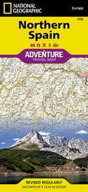
Wegenkaart - landkaart 3306 Adventure Map Spain Northern - Noord Spanje | National Geographic (9781566955386)

  • ISBN / CODE: 9781566955386
  • Editie: 01-12-2022
  • Aantal blz.: 1
  • Schaal: 1:380000
  • Uitgever: National Geographic
  • Soort: Wegenkaart
  • Serie: Adventure Map
  • Taal: Engels
  • Hoogte: 24.0 cm
  • Breedte: 11.0 cm
  • Gewicht: 93.0 g
  • Uitvoering: Scheur- en watervast
  • Beoordeling: 4,5 ★★★★★ ★★★★★ (4 reviews) Schrijf een review
  • 17,50

    Levertijd 2 - 4 werkdagen in huis in Belgie Levertijd Nederland Levertijd 2 - 4 werkdagen in huis in Nederland Levertijd Belgie

    Gratis verzending in Nederland vanaf €35,-

Beschrijving

Wegenkaart van Noord Spanje met vermelding van veel bezienswaardigheden, nationale parken en attrakties. Watervast en scheurvast. Juist door deze vermeldingen onderscheidt de kaart zich van andere wegenkaarten.

National Geographic's Northern Spain Adventure Map is designed to meet the unique needs of adventure travelers—detailed, durable, and accurate. Northern Spain includes the locations of thousands of major cities and towns with an index for easily locating them, plus a clearly marked road network complete with distances and designations for expressways, motorways, and more. St. James Way, one of the most important Christian pilgrimages during medieval times, is noted for travelers seeking to retrace to route to the Cathedral of Santiago de Compostela in Galicia where the remains of the apostle Saint James are believed to be buried.
 
What sets National Geographic Adventure Maps apart from traditional road maps are the hundreds of points of interest that highlight the diverse and unique destinations within Northern Spain. National parks, World Heritage sites, scenic viewpoints, archeological sites, forts, castles, churches, and more are included, making it invaluable to travelers hoping to experience all the history, art, and culture the region has to offer. Beaches and yachting harbors dot Spain’s extensive Atlantic coastline while the location of golf courses, camping sites, waterfalls, caves, and spas make it easy to enjoy the region’s abundant outdoor activities.


The front side of the Northern Spain map shows the eastern half of Northern Spain from its border with France on the north to the city of Tudela on the south. It continues west to Cangos de Onis and Palencia. The reverse side of the map stretches from Cangos de Onis and Leon to the region’s western Atlantic coast.

Reviews

Prima gedetailleerde kaart

Prima gedetailleerde kaart

★★★★★ door R. Nijssen 20 januari 2020 | Heeft dit artikel gekocht

Vond u dit een nuttige review? (login om te beoordelen)

-
Nee (0)
Meer up to date kaart was ECHT prettiger geweest

Ik reageer omdat ik eigenlijk ontevreden ben dat de kaart al 5 jaar gedateerd was. Dat betekent dat veel wegen er niet juist op stonden. Toezending en verwerking etc. is prima verlopen. Op vakantie is alles goed verlopen maar meer up to date kaart was ECHT prettiger geweest.

★★★★★ door E. Schonk 8 september 2016

Vond u dit een nuttige review? (login om te beoordelen)

-
Nee (0)
Veel detail en na lang gebruik nog steeds goed

prima kaart voldoende detail om routes te plannen. snel thuis door afhandeling door De Zwerver. kaart blijft ondanks opvouwen en gebruik zeer goed. De natuurparken zijn aangegeven.

★★★★★ door ron 20 januari 2015

Vond u dit een nuttige review? (login om te beoordelen)

-
Nee (0)
Toon meer reviews

Schrijf een review

Graag horen wij wat u van dit artikel vindt. Vindt u het goed, leuk, mooi, slecht, lelijk, onbruikbaar of erg handig: schrijf gerust alles op! Het is niet alleen leuk om te doen maar u informeert andere klanten er ook nog mee!