Mandje Tel: +31503126950 Menu
Winkelwagen
Geen items in winkelwagen
Ga naar winkelwagen

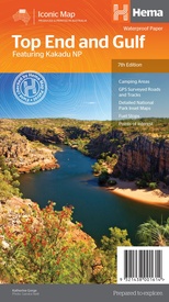
Wegenkaart - landkaart Iconic Map Top End and Gulf | Hema Maps (9321438001614)

Featuring Kakadu National Park

  • ISBN / CODE: 9321438001614
  • Editie: 01-07-2019
  • Druk: 7
  • Aantal blz.: 1
  • Schaal: 1:1650000
  • Uitgever: Hema Maps
  • Soort: Wegenkaart
  • Serie: Iconic Map
  • Taal: Engels
  • Hoogte: 25.0 cm
  • Breedte: 14.0 cm
  • Gewicht: 60.0 g
  • Uitvoering: Scheur- en watervast
  • Bindwijze: -
  • Schrijf als eerste een review
  • 15,95

    Leverbaar in 3 - 5 werkdagen in huis in Belgie Levertijd Nederland Leverbaar in 3 - 5 werkdagen in huis in Nederland Levertijd Belgie

    Gratis verzending in Nederland vanaf €35,-

Beschrijving

This regional waterproof map of the Top End and Gulf is ideal for discovering the northern parts of Australia's NT by 4WD. It includes a main map of the Darwin region, Judbarra / Gregory National Park, Nhulunbuy, Keep River National Park and Boodjamulla (Lawn Hill) National Park.
 
There is additional tourist information for Arnhem Land, the Roper River trek, Darwin region, Douglas-Daly district, Nature’s Way, Victoria Highway, Katherine Region and the Stuart Highway Region.
 
PRODUCT FEATURES
 
GPS surveyed roads and tracks
Fuel stops
Self-drive 4WD tracks
Camping areas
Historic sites
Detailed National Park inset maps
WHAT'S NEW IN THIS EDITION:
 
New edition, new layout
New cartographic map specifications
All inset maps are now provided in a better scale

Reviews

Geen reviews gevonden voor dit product.

Schrijf een review

Graag horen wij wat u van dit artikel vindt. Vindt u het goed, leuk, mooi, slecht, lelijk, onbruikbaar of erg handig: schrijf gerust alles op! Het is niet alleen leuk om te doen maar u informeert andere klanten er ook nog mee!