Mandje Tel: +31503126950 Menu
Winkelwagen
Geen items in winkelwagen
Ga naar winkelwagen

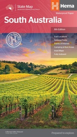
Wegenkaart - landkaart South Australia state map | Hema Maps (9781865009865)

  • ISBN / CODE: 9781865009865
  • Editie: 20-10-2014
  • Druk: 8
  • Aantal blz.: 1
  • Schaal: 1:1800000
  • Uitgever: Hema Maps
  • Soort: Wegenkaart
  • Serie: State map
  • Taal: Engels
  • Hoogte: 25.0 cm
  • Breedte: 14.0 cm
  • Gewicht: 63.0 g
  • Uitvoering: Papier
  • Schrijf als eerste een review
  • 15,95

    Op voorraad. Binnen 2 - 3 werkdagen in huis in Belgie Levertijd Nederland Voor 17.00 uur op werkdagen besteld, morgen in huis in Nederland Levertijd Belgie

    Gratis verzending in Nederland vanaf €35,-

Beschrijving

Mooie, duidelijke en uitgebreide kaart van South Australia.

Great for travel planning, Hema's South Australia state map clearly shows highways, minor and secondary roads, national and state routes and fully-indexed cities, towns and localities. Detailed road distances are also shown.
 
The flipside of the map features loads of insets covering various bits and pieces throughout South Australia including an Adelaide CBD and throughroads map, an Adelaide region map, a map of the Barossa Valley and the Flinders Ranges National Park. There's also a list of information centres giving their address, phone number and website.
 
The map features:
 
Camping areas
Rest areas
24 hour fuel locations
Outback fuel stops
Caravan parks
National parks
A full index
Points of interest
A distance grid

Reviews

Geen reviews gevonden voor dit product.

Schrijf een review

Graag horen wij wat u van dit artikel vindt. Vindt u het goed, leuk, mooi, slecht, lelijk, onbruikbaar of erg handig: schrijf gerust alles op! Het is niet alleen leuk om te doen maar u informeert andere klanten er ook nog mee!